In a splashy cover story this week, the quarterly magazine sent to thousands of local business leaders this week considers which Washington, D.C. neighborhoods will be the next “hot spots.” The story appears in OnSite, a quarterly glossy magazine sent to subscribers of the Washington Business Journal. With a password-only website, the story’s only readers […]
Rosslyn Redevelopment
Last Saturday I competed in second annual Real Estate Case Competition hosted by George Washington University’s Real Estate Investment & Development Organization. Sixteen universities created interdisciplinary teams to create detailed redevelopment proposals for a site in Rosslyn, Virginia slated for redevelopment. The property owners, Vornado/Charles E. Smith, participated in the judging of the entries and […]
National Security Sprawl in … Spotsylvania?
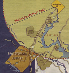 Spotsylvania County, some 50 miles from Washington, is positioning itself in newspaper advertisements as the next logical place for defense contractors to locate.
Are federal rules pushing ‘security sprawl’ to the next frontier of suburban development?
Ballston Examined
I completed this essay for the final assignment for my urban design class. The assignment was to conduct an analysis of this block adjacent the Ballston Metro Station in Arlington County, Virginia. My study area is part of the “Ballston-Rosslyn Corridor,” a nationally-known example of smart growth. Along the corridor, the county has added roughly […]
Describing D.C.’s ‘National Security Sprawl’
To Deborah Natsios, the September 11, 2001 attack on Washington ushered in a new epoch of national security sprawl. She traces the evolution of “war sprawl” in the region: the city’s circumferential Civil War forts, suburban WWII facilities, Cold War beltway and missile placements, and exurban defense industry office campuses. In Natsios’ account, the September […]
Interesting Freeway Interchanges of the Capital Region
American taxpayers have spent trillions of dollars building freeways since the passage of the National Interstate and Defense Highways Act of 1956. This network of freeways has re-shaped American cities, and arguably impacted the economy and culture of the country. While some enthusiasts find interest in the highway system’s endless strips of asphalt, for most […]
Skydome Report
As promised, I checked out a DC memorial to the 1970s I notice every time I cross the 14th Street bridge to Virginia. What icon is that? Why, the Crystal City Doubletree’s rotating lounge, of course. In an earlier era it seemed no self-respecting city lacked a rotating restaurant, preferably lodged high up in a […]