Metro’s Fares Analyzed

Posted: January 3rd, 2008 | Author: | Filed under: District of Columbia, Transportation, WMATA | 14 Comments »

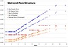
With the D.C. Metrorail’s fares set to increase on Sunday, it piqued my interest in precisely how the system determines charges and the nature of the changes. I decided to take a look at exactly what pattern the famously unpredictable fares took. While most news reports have reported suburban riders would experience the largest absolute increases, my analysis shows they continue to enjoying the lowest cost per mile of all riders, well below the cost of automobile use.

First as a note, while I support minimal user fees for public transit, I don’t have much patience for those who complain about any fare increase. The costs of running Metrorail — especially employee health insurance and electricity — have increased exponentially in recent years. However, funding from the area jurisdictions has not kept up. The agency was left with little choice than to raise fares to make up the difference. While the best solution might be a stable dedicated funding source, forcing austerity by blocking face increases would only compromise the system’s performance and reliability in the long term. Tight municipal regulation of fares was one reason the nation’s urban streetcar systems fell into disrepair in the 1930s and 40s, making them prone to purchase and closure by automobile companies. At the very least, WMATA should be able to adjust fares to keep pace with inflation (something the December decision allows).

To create these graphs, I analyzed the current and new fares for my home station, the Shaw-Howard University station on the Green Line. This set includes some trips that clock out at the new maximum fare — $4.50.

New Metro Fare Structure

The fares operate at a flat rate until the trip reaches about 3 miles in length, and then progressively increases until it reaches about 15 miles, where it remains at a maximum fare. The reduced (off-peak) fares are divided into three tiers, and will remain unchanged under the new plan.

While this graph makes it look as if urban riders are getting a subsidy and suburban riders must bear a high burden, a quick look at the fares per mile shows a quite different pattern.

Metrorail Cost Per Mile

Since most reliable estimates of the cost of operating an automobile range from $.50 per mile to $1.50 per mile, we can see most suburban commuters continue to enjoy costs substantially lower than driving if we exclude the more complex issue of speed. All this goes to make former WMATA Board Member T. Dana Kauffman’s claim the fare structure is a “raw deal” for suburban commuters all the more absurd.

Lastly, riders are familiar with the system’s estimated trip times, presented alongside the fares in stations and online. These times take into account train frequency and the number of transfers required. While I’m not sure exactly how they are created (and assume they mean peak times), I’ve found them to be roughly accurate. Using this data I have graphed the average trip speeds from the Shaw station.

Metro Average Speed

What do you think of the fare system and the increases?

> W. Post: Metro Passes Largest Fare Hikes in its History, Increases in Fares, Services Unequal
> WMATA: New station-to-station fares


Counting Metro’s Riders

Posted: December 7th, 2007 | Author: | Filed under: District of Columbia, Transportation, WMATA | 5 Comments »

We all know the D.C. Metro is busy. Thanks to a region-wide reach and decades of transit oriented development around many Metro stations, ridership of the Washington, D.C. Metrorail system is at record highs and growing. However, detailed data about the relative popularity of each station is harder to come by. How busy is each station, and how has popularity changed over time? Occasionally statistics are reported in the media, but data is not generally available.

However thanks to a friend I’ve obtained a spreadsheet showing the average weekday passenger boardings at all 86 stations in the Metrorail system, from its opening in 1977 to this year. The oldest data are counts completed by staff, but much of the recent data is collected by the fare gates and audited by outside consultants.

I’ve uploaded the data set to Swivel, a new service that hopes to be a social networking website for data. While it has many limitations, it does a good job at basic manipulations of this type of straightforward time series data. Let’s take a quick look. Here’s the total system ridership:

Average Daily Ridership

This data set contains graphs of the stations ranked by popularity each year. For example, here’s the 10 top stations in 1977, the year the system opened:

1977 by Station

Perhaps more interesting is this set, which shows the change in ridership at each station over time. In Chinatown, the opening of the Verizon Center and other development in the late 1990s has sparked a dramatic growth in ridership:

Gallery Place-Chinatown

Other stations have seen slower growth.

Dupont Circle

Many, like mine in Shaw, have experienced periods of ridership decline.

Shaw-Howard Univ

Of course, with Swivel you can also quickly compare various stations.

Green Line Ridership Growth

Take a look at the full sets online here: WMATA Ridership by Station, Ridership by Year


Does Washington Need a Planning Commission?

Posted: November 26th, 2007 | Author: | Filed under: District of Columbia, Public Policy, Urban Development | 3 Comments »

Planners from other cities are often surprised when I tell them that Washington, D.C. does not have a planning commission. Thanks to the city’s unique legacy as the home to the federal government, it boasts a convoluted system for regulating new building in the city that lacks a central planning body. The system is so complex that at times the city government itself forgets to enforce existing laws, and major new buildings on the National Mall can “take most Washingtonians and most Americans by surprise.”

Proposed South Capitol Street BridgeLet’s take a quick look at who’s involved. Starting at the federal level, the National Capital Planning Commission oversees all federal construction in the capital region, as well as creating long-term comprehensive plans focusing heavily on the location of the federal government. However the limited authority of the agency means the plan has little direct influence over private development in the city. For example, NCPC plans have proposed far-ranging ideas including a new mall along South Capitol Street that one blogger has even dedicated his site to discussing. I previously compared the NCPC’s hazy vision of the future with science fiction visions for our city.

While NCPC does not review private construction, another federal agency does review the aesthetics of some private construction. Private buildings in certain sections of the city (mostly abutting or facing federal property like Rock Creek Park and Pennsylvania Avenue) are subject to review by the U.S. Commission on Fine Arts under the Shipstead-Luce Act. It was a mix-up over this act that forced the District to purchase and tear down a private home last year.

For their part, the city’s Office of Planning (organized in the city government’s executive branch) creates a wide range of neighborhood and citywide plans including the recently completed 2006 Comprehensive Plan of the National Capital. The Mayor’s Deputy Mayor for Planning and Economic Development oversees redevelopment plans and other special programs. The District Department of Transportation creates special transportation plans and oversees the planning of transportation infrastructure. Construction in any of the city’s many historic districts is regulated by the Historic Preservation Review Board.

Construction not subject to the specific bodies above is regulated by the Department of Consumer and Regulatory Affairs that can issue a building permit for by-right construction conforming to the city’s zoning. Any planned unit developments or nonconforming projects must come before the quasi-autonomous Zoning Commission, and can be appealed to the Board of Zoning Adjustment.

Given this backdrop, the Washington Business Journal recently published two columns in their OnSite magazine arguing for and against creating a new planning commission. Dorn C. McGrath Jr., a professor emeritus from George Washington University, argues explaining this convoluted structure could be a primary task for the commission. He also thinks such a commission would help oversee the maintenance and development of city facilities, arguing, “It seems that ‘smart growth’ now extends only to the low-hanging fruit of new condo and shopping center development, rather than the untidy business of planning for needed parks, recreation facilities, vehicle storage and maintenance and schools.”

Arguing against is Ellen McCarthy, who served as director under the Office of Planning for Mayor Anthony Williams. She boasts the city already has a “high-functioning planning structure” and questions the benefit of adding a new commission to the mix.

While I don’t think it is likely a commission will be created anytime soon, the debate is important because it sheds light on advantages and drawbacks of the existing system. The two viewpoints are shown below.

Does D.C. need a planning commission?

Yes by Dorn C. McGrath Jr.

D.C. urgently needs what a planning commission might one day provide, but now is not the time. A planning commission needs the political support of the mayor, and recent events tell us a planning commission is on the mayor’s back burner, if on the stove at all.

Why does the District need a planning commission? It would help educate the city government, developers and citizens in every neighborhood about the planning process, which currently is not well understood. Yes, we have a comprehensive plan, but it is, in effect, a triumph of good graphics and ballyhoo over substance. A planning commission could help citizens and public officials understand this and set their sights higher. The D.C. Council vacuously cites the comprehensive plan, but always manages to find a way to defer final action on anything the plan suggests. Then, in haste, it adopts whatever has emerged. This amounts to political flatulence, rather than legislating as the law requires.

A planning commission for the District would provide some parity with the National Capital Planning Commission, a heavily funded agency interested primarily in the federal government’s holdings. The NCPC also calls the shots, ultimately, on whatever the local planning and development office produces in the way of a comprehensive plan.

There is no legal barrier to the city establishing a planning commission. The power of the mayor to do exactly this was confirmed in a 2003 legal opinion by Covington & Burling. Copies of that memorandum of law written for the Committee of 100 were furnished to members of the Council, then-Mayor Tony Williams and Office of Planning officials. They ignored it. The same memorandum was given to the current mayor and his director of planning. They, too, have ignored it. A planning commission might, after all, provide some sort of check on the mayor’s and deputy mayor’s adventures in development.

The city will probably continue to function as it does today without a planning commission. Emergency repairs to failing infrastructure, expensive (mostly speculative) development schemes, an unplanned baseball stadium, and sporadic treatment of selected sites along New York Avenue have become the city’s modus operandi. Meanwhile, the city continues to tolerate the nuisance of an illegally operated trash-transfer facility on Brentwood Road, just opposite the Israel Baptist Church.

The city also has chosen to put aside the messy problem of Department of Motor Vehicle operations, many of which are now crowded into an obsolete, ill-paved shopping center beside the trash-transfer facility. DMV inspectors are reduced to authorizing illegal parking in the shopping center and to conducting their driving tests on overloaded public streets. It is noteworthy that the original testing facility was much larger and located across Brentwood Road, but was compressed and relocated to make room for new development on the Rhode Island Avenue/Brentwood Road site in Northeast.

It seems that “smart growth” now extends only to the low-hanging fruit of new condo and shopping center development, rather than the untidy business of planning for needed parks, recreation facilities, vehicle storage and maintenance and schools.

Mayor Fenty is to be applauded for his valiant effort to take over the embarrassing public school system, but the citizens are still holding their breath to see if he and his new chancellor succeed. In the meantime, many wonder what types of schools will serve whatever types of occupants there may be in the vast number of condominiums that have been built in various locations throughout the city.

Washington is, and will remain, a fragmented city. It is divided between the federal city, which is governed mainly by Congress and the securicrats, and the rest — which is about half — governed to a certain extent by the city government. The city’s budget, never a certainty, is still subject to approval by Congress. A planning commission would be of some help in assuring Congress that there is some relationship between the proposed budget and actual capital improvements, many of which are badly needed. The planning commission would bring a degree of professionalism to the process of government, and begin, at last, the long task of educating officials and the public all across the city about planning per se as a basic obligation of government. The present lineup at OP can’t, and won’t, do this.

When he first came to town from Oakland, Calif., to fill the post of city administrator, Robert Bobb inquired of a group of citizens, “Why doesn’t Washington have a planning commission — nearly every other big city has one?” By now he understands, I’m sure.

Dorn C. McGrath Jr. is professor emeritus at George Washington University. He is a fellow of the American Institute of Certified Planners.

No by Ellen McCarthy

Proponents tout a planning commission for Washington as a cure for all perceived planning ills. Indeed, such commissions are part of the planning process in many, though by no means all, large American cities. D.C., however, already has a high-functioning planning structure, so in order to justify change, we must be clear about what a planning commission can — and cannot — do for Washington.

Many of the arguments for the commission relate more to policy disagreements with the Office of Planning than to identifying holes in the present system that could be fixed by a volunteer planning advisory group.

The District already has a good system of planning checks and balances. The Home Rule Charter designates the mayor as chief planner; the mayor has delegated that power to the Office of Planning, which currently has more than 70 staff positions. OP prepares plans for neighborhoods, maintains a state-of-the art geographic information system and Census data, does long-range planning and prepares a report on every case that goes before the Zoning Commission or Board of Zoning Adjustment.

The charter provides for a Zoning Commission that adopts amendments to zoning regulations, changes to the existing zoning classifications and new overlay districts and also reviews campus plans and proposed planned unit developments. D.C. is unlike most jurisdictions in that its Zoning Commission’s decisions do not go before the council for a vote. They are final, except for appeals to the courts. The Board of Zoning Adjustment grants variances or special exceptions when circumstances make it difficult to abide by the zoning regs.

The touchstone of the entire system is the comprehensive plan, which is prepared by OP, proposed by the mayor, adopted by the Council, and reviewed by National Capital Planning Commission and Congress. In addition to policy goals covering transportation, economic development, urban design, etc., the comp plan includes a map specifying land use and intensity for every parcel in the District. Legally, zoning “may not be inconsistent” with the plan.

One of the major benefits of planning commissions in some cities is to provide objective input on development proposals, frequently as a counterpoint to elected bodies subject to pressure from campaign contributors or small but vocal groups of neighbors. In our case, the Zoning Commission plays this role, largely insulated from political pressures, but still accountable. The mayoral appointees serve specified terms, and can be blocked by the mayor or the Council. The federal representatives are ex officio, and are not beholden to campaign contributors or NIMBYs.

The only major areas left out of ZC review are the comp plan and small neighborhood plans. After extensive public input, these go directly to the Council for review and adoption. Although the Council holds public hearings on these, some planning commission advocates consider this to be insufficient opportunity for public input. It’s a hard argument to make — on the comp plan, for example, there were a Citizen Advisory Commission, three multihour public hearings, two Council votes, dozens of meetings with citizens and local Advisory Neighborhood Commissions and a Web site that received more than 2 million hits.

Some advocates of a planning commission even envision it making recommendations to the Zoning Commission on individual projects. Adding yet another review level to a project that may already be undergoing review by the local Advisory Neighborhood Commission, the neighborhood association, the Office of Planning, the Historic Preservation Review Board and the Zoning Commission or BZA would not serve to encourage investment in our neighborhoods.

Finding qualified members would also be difficult. The number most often suggested is nine. Those members would need some expertise in planning issues and would have to be broadly representative of the city. As it is, there is difficulty in getting the right appointees for the ZC, BZA and HPRB.

And if the planning commission’s staff were to number more than a handful, there would be the possibility of competing planning agencies, creating an unnecessary expense and replicating existing capabilities.

The District is blessed with a professional planning staff and a system of checks and balances. A planning commission might provide for additional public input and objective recommendations to the Council for small-area plans and the comprehensive plan — if sufficient qualified people could be persuaded to serve and if the scope and staffing were carefully managed to avoid unproductive bureaucratic in-fighting. And those are big ifs.

Ellen McCarthy is director of planning and land use in the real estate section at Nixon Peabody. McCarthy served as director of the Office of Planning under then-Mayor Tony Williams.


Help Plan a New Shaw Library

Posted: November 7th, 2007 | Author: | Filed under: DC Shaw Neighborhood, District of Columbia, Watha T. Daniel Library | 2 Comments »

Watha T. Daniel LibraryAs noted by a visitor in a recent comment, at long last a fully equipped temporary Watha T. Daniel/Shaw Library has opened at 945 Rhode Island Avenue next to the Shaw Junior High School.

The grand opening is next Wednesday, November 14th from 4 to 5:30 p.m., to be followed by a “Hopes and Dreams” meeting to “solicit community input about the service priorities desired in the soon to be constructed Watha T. Daniel/Shaw Neighborhood Library” that will take the place of the old library shown here. For more information contact Archie Williams at archie.williams at dc.gov.


O Street Market Redevelopment

Posted: October 24th, 2007 | Author: | Filed under: DC Shaw Neighborhood, District of Columbia, Urban Development | 10 Comments »

Although some Shaw blogs have already posted some of these images, I thought readers would be interested to see the first architectural renderings of the redevelopment planned by Roadside Development for the site currently occupied by the Shaw Giant Supermarket, and the ruins of the 1881 O Street Market (more). The company has dubbed the project “CityMarket.”

The project is planned to contain 601 apartments and condos, a 200-room hotel, and a 56,000 square foot supermarket. It will also, in the developer’s words, “will spark the redevelopment of the historic Shaw community by providing two and one half levels of underground parking … The required parking under District zoning would be approximately 300 spaces while 700 spaces will be provided.”

O Street Market

CityMarket Perspective

CityMarket Site Plan

CityMarket Cross Section

CityMarket Elevations

CityMarket


Washington’s Urban Facelift

Posted: October 16th, 2007 | Author: | Filed under: District of Columbia, Pedestrian Space, Transportation, Urban Development | 9 Comments »

With over 250 city blocks totally rebuilt by work crews over the past five years, Washington, D.C. is in the middle of a major urban facelift.

Without fanfare and below the radar of many urban observers, Washington is in the middle of a period of significant street reconstruction and enhancement. In neighborhoods across the city, city officials are repaving streets, rebuilding sidewalks, and installing new lamp posts, parking meters, plazas and streetlights.

Street improvements are an unloved necessity of urban life. Inconvenient and messy, these so-called “streetscaping” improvements are as unglamorous as they are important to the creation of a pleasant public realm. This photo from a project on P Street in Dupont Circle taken last August illustrates just how disruptive the work can be – note the haze was caused by dust in the air.

P Street Streetscaping

Some brief statistics from D.C. Department of Transportation’s online street construction project database suggests the scope of the work. City contractors have totally reconstructed 255 blocks in the past five years, 45 blocks are currently under construction, and 21 more are already in the pipeline for the next year.

Proposed Bike Routes and LanesOther improvements are also being made. Some 1,500 crosswalks are now equipped with countdown timers, more than any other U.S. city we are told. Newly constructed bike lanes crisscross Midcity neighborhoods and Capitol Hill, with plans for more in the works. (Proposed routes and lanes are shown to the right.) New parking meters have appeared in Georgetown and new streetlights in Dupont Circle. Such improvements caused the DC Sidewalk Blog to declare “state of our sidewalks is strong” at the start of the year.

U Street Streetscaping PlanIn just a few years, city residents can look forward to much needed improvements in several high-visibility neighborhoods. Dupont Circle’s P Street was rebuilt over the summer, causing some complaints by local businesses. Planning is well underway for a comprehensive streetscaping project for U Street NW and H Street NE, with re-designed intersections, widened sidewalks, and new streetlights. At South Capitol Street, the city spent $27 million last summer to lower an elevated freeway to make other improvements near the new baseball stadium.

A civic plaza with an interactive fountain and public art is planned for a space near the Tivoli Theatre in Columbia Heights.
Columbia Heights Civic Plaza Plan

In addition to physical improvements, the city has hired a consultant to prepare a first-ever pedestrian master plan, which includes detailed analysis of pedestrian injuries, missing sidewalks, and interviews with residents walking the streets along key corridors. Hopefully this document will help set the agenda for future improvements.

Carter G. Woodson ParkThe missing element in all of this is the sad state of many of the city’s public parks, epitomized by the neglected Carter G. Woodson Park near my house. (With the possible exception of the new Georgetown Park under construction.) The recently launched CapitalSpace initiative seeks to improve and connect the city’s parks to create a true citywide system. The group’s work is cut out for them. This part of the public realm presents many challenges: coordinating between bureaucracies, managing eclectic neighborhoods, navigating conflicting citizen needs, and confronting the problem of homelessness. Tackling those problems are much harder — and potentially more important — than hiring a construction crew to lay down new bricks and tree boxes.

jpeg.JPG
Quite a few online loans are available from various banks. They may be secured or unsecured loans, depending upon the subject’s statistics. One often needs banking and finance reference before allowing processing of such loans. Most of the banks also offer a loan guaranty service. The ones that get processed most easily are the home equity loans.


Information Design and Public Transit

Posted: October 5th, 2007 | Author: | Filed under: District of Columbia, Transportation | 19 Comments »

City BusThe Washington, D.C. public has an aversion to public buses, particularly Metrobus operated by the Washington Metropolitan Transit Authority.

Does the region have an inherent bias against buses? A few bus routes are extremely well used in both high and low income neighborhoods (the 30s accomplishes this in one line). Furthermore, the DC Circulator, Georgetown Blue Bus, and other bus services have shown commuters, tourists, businessmen, and others will take a certain type of bus. The reasons most often cited for not riding the bus generally include irregular service, infrequent service, inferior user experience, and uncertainty about route paths and schedules. Unfortunately, the Metrobus system needs improvements in each of these areas.

Successful modern bus systems (Whether known as bus rapid transit or other names) are designed to address precisely these concerns. They generally feature frequent, regular service with new buses along clearly defined routes. Metrobus itself rolled out one of these routes on Georgia Avenue: Metro Extra. While the regular Metrobus service clearly needs comprehensive improvement before many of the routes see additional ridership, there is one part of the package that is relatively cheap to implement: information.

The quality of information made available to the public about Metro’s bus service is exceedingly poor. Data available to the riding public comes in several categories, and a brief survey will demonstrate its severe inadequacy.

First, the online Trip Planner on WMATA.com will suggest bus routes based on times and addresses, however it is based on buses scheduled arrival and departure times. The knowing Washingtonian will rarely use these schedules and know intuitively that even if on paper the bus should be faster, in reality walking or Metrorail is frequently be quicker. Furthermore, the Trip Planner provides little sense of frequency: is the bus it suggests the only one that hour, or do they come every 10 minutes? Such details must be provided to the riding public. This lack of context problem also plagues technical systems like NextBus. The limited data prevents rider judgement and if it is broken or the bus comes off schedule the rider is out of luck. Nextbus also reports each bus route separately, even though by design many separate routes overlap for long distances.

Second, Metro publishes a systemwide bus map that is available as a PDF on its website and distributed at stations. The distribution of paper material at Metrorail stations is seemingly random – station managers seems to stock whatever they’ve got lying around. The webpage where Metro publishes the bus map contains not one but six different types of maps showing the much simpler Metrorail system (which itself contains in stations and trains far more maps than exist on buses). Most buses do not contain a map of the route you’re on, let alone the system. Clearly, part of the solution must be distribution: every bus must have route and system maps available. Metrorail stations should always have bus system maps available. Even if you get your hands on one of these things they may not help. Try to keep your eye on one route in this detail of the systemwide map:

Metrobus Map

The suburban portions are often no better, leaving off many minor roads. This detail of a map will illustrate their limited usefulness: where does the bus turn at those intersections? Which lines are for the F4 and which the F6? It’s little wonder this particular route runs frequently with empty or near-empty buses, despite high demand along the corridor.

Detail F6 Map

Contrast those with this detail from the Circulator:

DC Circulator Map Detail

While it is true the amount of information displayed is much less, the difference in quality is striking. The Circulator map tells riders where the stops are, which direction the bus travels, and exactly how the route relates to Metro stations and landmarks.

F6 Timetable DetailThird, Metrobus publishes a pamphlet containing the timetable and a route map. The Express’ Mike Grass recently rightly called Metrobus’s timetables “perhaps the most user-unfriendly piece of paper known to man.” Only a transportation engineer could find the mind-numbing lists of numbers like the one at the right meaningful. Even experienced riders like myself sometimes get confused. Metrobus also only publishes bus times for a handful of points along the route – riders in between must rely on experience or mental extrapolation to know when the bus might show up if their stop isn’t on the table.

F6 ScheduleIs there a better way to convey this information? Design guru Edward Tufte thinks so. Tufte has built a career on three lavishly illustrated books describing what he describes as “information design.” His book Envisioning Information compares a traditional timetable of the sort shown above with one from a Japanese train schedule. Unlike conventional timetables which seek to contain too much information and thus convey none, this schedule was for just one station. The hours ran down the center and a series of numbers corresponding with the minutes past the hour the train left were stacked to the left or right of the hour, depending which way the train was going. The technical term for such charts is a stem and leaf, but regardless it brings meaning to the times.

To the right, the timetable shown above is converted into this type of chart. On this route, there are generally more buses during rush hour. Furthermore, once the viewer figures out the layout it conveys the information much more efficiently than the tables – if you’re traveling after 8 p.m. to Silver Spring it’s immediately apparent there’s only two more buses.

The more frequent the bus service the more useful this type of display becomes. For example, the University of Maryland Shuttle from the Metro Station to campus timetable is below on the left. To the right, a redesigned version.

Shuttle-UM Route 104 TimetableRedesigned Shuttle UM Timetable

The new table immediately communicates the type of information many riders are looking for but is hidden in the long list of times: frequency. It explains why it always seems to take longer when I get to the station around 11 a.m., and also makes immediately apparent the reduction of service after 8 p.m.

Of course, while such information improvements are inexpensive and would no doubt encourage ridership Metrobus has much more serious problems. Its bus fleet is old, the routes badly need rationalizing, and the “customer service” of many drivers leaves much to be desired. One local jurisdiction which seems to fully grasp the importance of information is Arlington County, which operates a constellation of various websites and host of offline efforts targeting county residents encouraging and explaining transportation choices.

The Washington, D.C. region has invested millions of dollars in extensive public bus systems. Isn’t it time we make them easier to use?

Blog Widget by LinkWithin